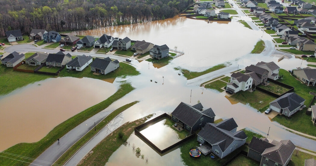
A storm bringing torrential rain, dozens of tornadoes and dangerous flooding has swept across the central United States for days, and is expected to continue battering the region on Saturday, forecasters say.
Officials are preparing for rain, high winds, hail and potential flash flooding from East Texas and Louisiana up through the Ohio Valley to southwestern Pennsylvania, according to the Weather Prediction Center.
The storm has already wreaked havoc across those regions, killing at least eight people, including a 9-year-old boy who was swept away by floodwaters in Frankfort, Ky. The heaviest rain so far, which has caused dangerous flooding, mostly fell in Arkansas and southern Missouri. Recovery efforts have been stunted in some areas by the weather, which may taper off through Sunday.
Wet weather is expected from East Texas to New York on Saturday, with the heaviest rains in Arkansas, the Missouri Bootheel, western Kentucky and Tennessee.
That region has already had days of rain, with some areas recording up to nine inches, well above what many of these places usually receive in the entire month of April.
The ground is saturated and can no longer absorb the rain, which means it “has nowhere to go and it runs off and creates more flooding,” said Frank Pereira, a meteorologist at the Weather Prediction Center.
On Saturday morning, Mr. Pereira said that storms were developing and moving across eastern Oklahoma, northeast Texas, Arkansas and western Tennessee. Some of these areas could see several more inches of rain, he said.
The storms could also generate damaging winds, unleash large hail and spawn tornadoes. The area at risk for severe thunderstorms stretches from the Sabine River Valley northeast into the Mississippi and Ohio Valleys.
“Folks are going to have the potential for really all modes of severe weather, from tornadoes to damaging straight-line winds, up to large hail,” said Scott Unger, a meteorologist at the National Weather Service in Nashville. At times, the hail could be as large as golf balls, he said, with severe weather potentially lasting well into Saturday night.
The National Weather Service also warned of life-threatening flash flooding across the region and urged people to turn around if they came across washed-out roads, adding that most flood deaths occurred in vehicles.
Cities across the storm’s path, which include Little Rock, Ark.; Jackson, Miss.; and Memphis, are bracing for the worst. Mayor Craig Greenberg of Louisville, Ky., said in a news release that he expected the Ohio River to rise about 30 feet. Officials in St. Louis County, Mo., said that part of Interstate 44 would most likely be underwater by Sunday. Officials in Paducah, Ky., said they were installing floodgates and getting more pump stations.
In Louisville, Ky., the region’s sewage utility said the sewer system had reached capacity because of heavy rain, and asked customers to refrain from running washing machines and dishwashers.
While the looming rains were worrisome, people in affected areas were contending with the damage that had already been done. On Friday, Sydney Metz, a Nashville resident and a graduate student at Vanderbilt University, was mostly concerned about how to get to her classes and her part-time job next week, because her car was waterlogged and wouldn’t start.
“Our yard completely flooded,” she said on Friday. “Just a whole rushing river.”
In New Madrid, Mo., Nick White, the mayor, said on Friday that the weekend storm could bring one of the most severe floods in the history of the city, which lies on the Mississippi River. He was preparing the city for a substantial rise in the river.
“We’ve got backup generators, we’ve got a backup pump,” Mr. White said, adding, “We’ve been really proactive versus reactive.”
The death toll climbed throughout Friday. At least five were killed in Tennessee, including a teenage girl. A man was killed in Danville, Ind., after coming into contact with downed power lines. Garry Moore, a fire chief in Whitewater, Mo., was killed on Wednesday responding to tornado damage.
Frank Pereira, a meteorologist with the National Weather Service, said on Friday morning that the heaviest rain had fallen throughout Friday and would continue through the first half of Saturday.
Severe thunderstorms are also possible on Saturday, extending into the Gulf Coast areas of Texas and Louisiana.
The stormy weather is expected to shift east on Sunday, giving the central United States a break. While there’s a chance for rain along the East Coast, the heaviest rains are expected in the southeast from the Gulf Coast to the Southern Appalachians. The flood risk is not as high as it was in the central United States on Friday and Saturday.
Jamie McGee, Carly Gist, Mitch Smith and Jonathan Wolfe contributed reporting.
